| Issue 4 |
For almost ten years, the Department of Engineering Science has undertaken collaborative research with the Institute of Environmental Engineering, Peking University, and the Yellow River Conservancy Commission, China, on the sustainable management of water resources in the Lower Yellow River. By interpreting hydrological data, we have found that the Lower Yellow River is unable to meet its primary requirements for sustainability.

|
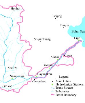
| Figure 1: The Lower Yellow River downstream of Sanmenxia to the Bohai Sea |
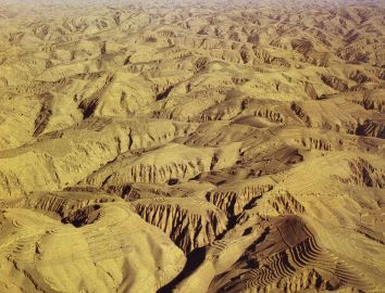
The Yellow River is over 5000 km long, and flows from the Qinghai-Tibetan Plateau to Bohai Bay (Figure 1). Its catchment area occupies the arid and semi-arid North China Plain, which is composed of land recovered from an earlier epicontinental basin that became filled with sediment. Until dykes and levees were constructed, the river was free to find its way to the sea, and often migrated, leading to an enormous alluvial area along China's eastern seaboard. The annual runoff in the Yellow River has a mean volume of about 58 billion m3, and varies from 14 to 86 billion m3. The river transports a mean annual load of about 1.6 billion tons of fine yellow sediment that originates mainly from the Loess Plateau (Figure 2) in Shanxi and Shaanxi Provinces. The Loess Plateau has a total area of 640,000 km2, of which more than 70% is eroding. Geological uplift driven by neo-tectonic movement is promoting extensive gravitational erosion, partly by rockfalls and landslides. Further man-made erosion is occurring as an indirect consequence of regional development. As a result, the tributaries feeding the Middle Yellow River contain hyper-concentrated levels of suspended sediment. Downstream of Sanmenxia, the sediment-laden Lower Yellow River meanders eastwards past the major cities of Zhengzhou and Kaifeng, through Shandong Province, until reaching the Bohai Sea.

|
| Figure 2: Loess region: Middle Yellow River |
Due to the river slowing and depositing sediment, the bed of the Lower Yellow River has risen to a level that is about 5 m on average higher than that of the land outside its dykes. This phenomenon is often referred to as the "hanging river". At Kaifeng and Xinxiang, the riverbed is respectively 13 and 20 m higher than street level. Worse still, as the breadth of the Lower Yellow river converges from 24 km to 0.3 km so does its local flow capacity, which falls from 22,000 m3/s to 11,000 m3/s in its lower reaches. Over the centuries, the Lower Yellow River has gained an awesome reputation for disastrous floods and for changing course. Extensive flood control works have been constructed, protecting an area of about 120,000 km2. Even so, more than 50 major floods, 1500 dyke breaks, and 20 changes of course have been recorded in a period of about 2500 years. In one flood in 1642, more than three hundred thousand people died at Kaifeng. Analysis of the historical data has shown that the river breaches can be classified as follows: dyke overtopping; scour caused by the river main channel being directed against the dyke walls; dyke collapse due to piping, seepage and leakage; ice-jam breaches affected by freezing and thawing of the river water; and man-made breaches (such as in 1938 when the dyke at Huayuankou was destroyed and 890,000 people perished, in an attempt to prevent Japanese occupation). After the founding of the People's Republic of China in 1949, all the dykes of the Lower Yellow River have been strengthened and had their crest elevations raised a total of four times. Even so, although the dykes are reasonably safe against overtopping and ice-jam breaching, they require further renovation to prevent scour or collapse-induced breaches.
Over the past few decades, the Lower Yellow River has begun to lose its vitality. Runoff into the river has decreased due to water storage and sedimentation of upstream reservoirs, changes in land-use, and warming of the central Asian climate. There may also be a contributory effect from a combination of uplift of the Qinghai-Tibetan Plateau and a lowering of the water table. Meanwhile agricultural, domestic and industrial water consumption has more than doubled, in step with socio-economic development. The river flow has reduced so much that no-flow and nearly no-flow events occur frequently. To date, the worst year for no-flow events was 1997, during which no water flowed into the sea for 226 days. That year, the maximum no-flow river length was 700 km, almost equal to the entire length of the Lower Yellow River. Low flows cause water shortages, and increase sedimentation, thus raising the riverbed level and bringing about an increased risk of flooding. The rapidly changing behaviour of the river makes it impossible to use past hydrological data to predict flood discharges sensibly. For example, a flood event that ten years ago had a one-in-a-hundred-year return period may now have a one-in-two-year likelihood of occurrence. High levels of effluent discharge into the Lower Yellow River combined with its reduced flow discharge have caused the water quality to deteriorate, and the eco-system to degrade. Desertification is taking place near the river mouth, where the exposed bed has become arid and wind-driven erosion is starting to occur. The coastal zone has also been severely affected, to the extent that previously offshore oilfields are now located inland.
Water resources management and flood control of the Yellow River are the responsibility of the Yellow River Conservancy Commission, which in turn reports to the Ministry of Water Resources and thence to the Central Government of China. After 1949 a flood control system was established with dams storing water in the upstream reaches and more than 1000 km of dykes reinforced along the lower reaches. Soil and water conservation measures were implemented, including the construction of 112,000 warping dams (to trap sediment) and more than four million water retaining structures. This brought about a decrease of about 300 million tons per annum of sediment entering the river. Recently, the Ministry of Water Resources altered the management framework from one of water conservancy to one of sustainability. Wang Shucheng, Minister of Water Resources stated the following four objectives for the Lower Yellow River: (1) the dykes should not be breached; (2) the river should not experience zero flows; (3) water quality should meet the required standard; and (4) the riverbed should not rise further. As a result, the Yellow River Conservancy Commission is presently developing a long-term strategy for the sustainable management of the Yellow River, supported by scientific, engineering, socio-economic, legal, and political inputs. A unified approach is being taken to water resource management, allowing for the fact that the river passes through several provinces. Countermeasures such as variable water pricing, restrictions on water consumption, engineering works such as the flood control and sediment flushing system at Xiaolangdi reservoir, dyke strengthening, additional sediment check dams, river training works, and flood warning systems are being implemented in the context of a sustainable water management system for the Lower Yellow River. But are these sufficient? In China, a huge effort has been directed towards understanding and mitigating the problems of the Yellow River. People have begun to debate whether the no-flow phenomenon is a sign that the river is unsustainable, or even dying. The Yellow River Conservancy Commission estimates that by 2010, the total water consumption may reach 52 billion m3 per annum, leading to a shortfall of more than 10 billion m3, given 42 billion m3 available for supply in a moderately dry year. With this in mind, the Yellow River Conservancy Commission has developed a three-pronged approach to managing the Yellow River, where the prongs are the river itself, a digital model, and physical model studies of the Loess Plateau, Xiaolangdi and Sanmenxia reservoirs, main channel and estuary.
Joint research is being carried out between the Institute of Environmental Engineering at Peking University, the Yellow River Conservancy Commission, and the Department of Engineering Science at Oxford University to assess the overall sustainability of the Lower Yellow River. To this end, we propose the following diagnostic tools: the concepts of minimum water demand for river sustainability (i.e. the minimum flow rate needed for the river ecosystem to flourish), functional no-flow events (flows that are too weak to sustain the ecosystem), river resource functions (that classify the flow into functional headings such as water available to the ecosystem, water required for socio-economic purposes, and excess flood water), and an integrated river health index. These tools have been applied to the Lower Yellow River using flow discharge data from four hydrological stations. In particular, the integrated river health index attempts to take account of the major factors that affect the condition of the river, including the annual functional no-flow river length (a parameter that reflects the relative severity of no-flow events), annual sediment carrying capacity, water available for the ecosystem, and water demand for socio-economic purposes. Interpreting the data, we found that, on average, ever since 1990 the minimum water demand for river sustainability has not been satisfied along at least half of the Lower Yellow River.

|
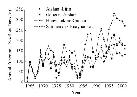
| Figure 3: Annual functional no-flow days: 1964-2001 |
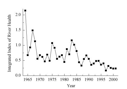
Figure 3 gives a plot of the number of functional no-flow days per annum recorded in four reaches of the Lower Yellow River in the years from 1964 to 2001. There is a noticeable upward trend in the number after 1985, particularly for the Aishan-Lijin reach closest to the mouth of the Yellow River. It appears there is a possibility that the Yellow river could become permanently disconnected from the sea. By converting river discharges into river resource functions, we find that the river was no longer capable of supporting further regional development after the 1980s and as a consequence the condition of its ecosystem had weakened significantly. By 1990, the water demand essential for the river ecosystem could not be satisfied even if the water resources were distributed evenly during the whole year and there was no water loss due to floods. However, extreme flood events have continued unabated, even though runoff has sharply decreased, indicating that the normal river functions have been severely impaired. Figure 4 shows the behaviour of the river health index in the period from 1964 to 2001. For the river to be sustainable, the index must have a value of at least unity. It is obvious that the condition of the Lower Yellow River has declined drastically since the 1960s. After 1970, the river health index is generally below 0.5, and only sporadically reaches the 1950s standard. After 1990, the river system is in a dreadful condition. The lowest point occurs in 1997, when runoff was the lowest recorded, no-flow events were most prevalent, water shortage caused large economic losses, and the ecosystem suffered great damage. In 2001, the upstream dam at Xiaolangdi became operational, and considerably improved the water and sediment conditions in the Lower Yellow River. However, although no zero-discharge events have occurred after 1999, the evidence from Figure 4 is that the river health index has remained at a very low level since then. It appears that the Lower Yellow River's ability to meet its eco-system and socio-economic requirements is exhausted.

|
| Figure 4: Integrated River Health Index for the Lower Yellow River since 1964 |
In conclusion, our results confirm that the Lower Yellow River is not sustainable at the level it had in the 1950s, and has declined to the point that it is unable to meet any of its primary functional requirements even after the implementation of recent countermeasures.
In the future, it may be possible to store water in Dongpinghu Lake (to the south of the Lower Yellow River) for release in times of drought. Additional water could be supplied from the western route of the South-to-North Water Transfer Project. Groundwater may also be abstracted in dry years, provided it is replenished in wet years. By changing agricultural practice, the demand for irrigation water could be reduced. Selective discharges from proposed upstream reservoirs at Qikou, Gu'xun, and either Dalishu or Xiaoguanyin could control the ratio of water to sediment in the river and so help prevent sedimentation. By means of flow diversion, it may also be possible to scour the riverbed near the estuary. Further levees and warping dams may be constructed to counteract the sediment supply from the Loess Plateau. To this end China's Ministry of Water Resources has proposed the construction of 60,000 warping dams by 2010, a monumental task. Finally, to improve water quality, limits must be placed on the total effluent discharge into the river from each province, backed up by proper monitoring and effective legal measures. Further research will be undertaken to ascertain whether these are likely to achieve their aim.
The author would like to thank Professor Jinren Ni of Peking University and Professor Guoying Li of the Yellow River Conservancy Commission for their input with regard to this article.
| << Previous article | Contents | Next article >> |
| SOUE News Home |
Copyright © 2005 Society of Oxford University Engineers |
SOUE Home |